
by Tanu Kumari, Kranthi Kumar Challa, Shweta, Amit Kumar Srivastava
In a world where food demand is soaring, yet arable land is shrinking, technology is redefining how we monitor and manage crops. One of the most promising innovations in precision agriculture is the use of drones—Unmanned Aerial Vehicles (UAVs)—to detect crop stress and predict yields with enhanced accuracy.
Unpredictable Crop Stress
Agriculture is increasingly challenged by abiotic stressors like water scarcity, nutrient deficiencies, and extreme climate events, which account for nearly 50% of global crop yield losses. In India, where rice and wheat form the backbone of food security, farmers rely heavily on traditional labor-intensive monitoring methods, which are often inadequate for large-scale farming. Satellite imagery, while useful, frequently lacks the resolution needed for early stress detection. This is where UAV-based remote sensing steps in as a game-changer.
Drones and Data: A Precision Approach to Farming
Drones equipped with multispectral, hyperspectral, and thermal sensors offer high-resolution, real-time data for crop health monitoring. These aerial tools capture data on plant stress indicators—such as canopy temperature, chlorophyll levels, and soil moisture—long before symptoms become visible to the naked eye. Farmers can optimize fertilizer use, irrigation schedules, and pest management by integrating this information with machine learning models, leading to healthier crops and improved yields.
Bringing Innovation to the Fields of Bihar
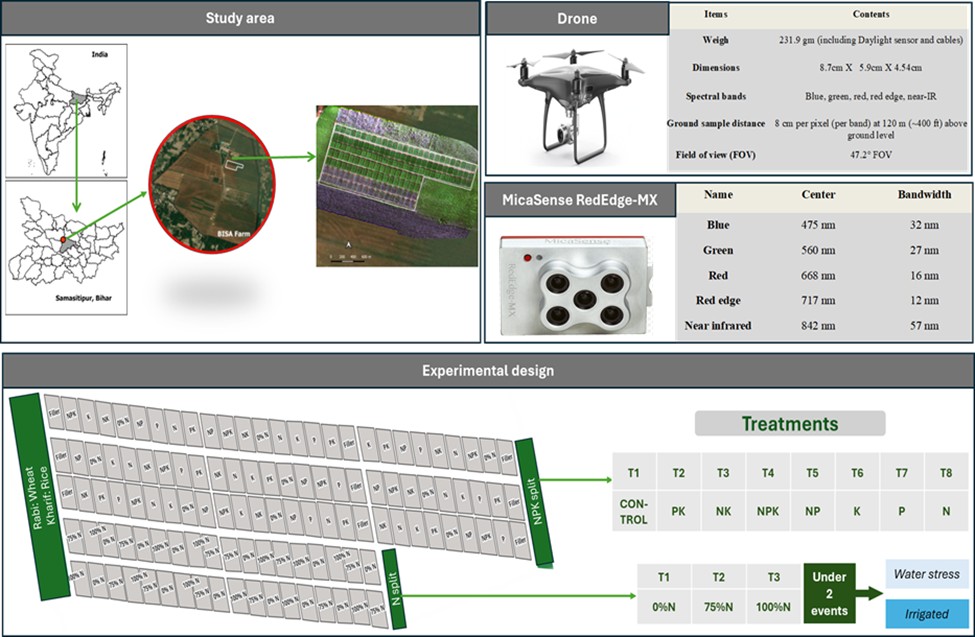
A recent study conducted at the Borlaug Institute for South Asia (BISA) in Bihar, in collaboration with the International Rice Research Institute (IRRI), tested the effectiveness of UAV technology for stress mapping and yield prediction in rice and wheat, which is a dominant cropping system in the Indo-Gangetic Plains of India. The study, spanning two years (2022-2024) and four cropping seasons, examined how different fertilizer treatments and irrigation strategies impacted crop health.
The experiment divided fields into two sections: one focused on the impact of Nitrogen-Phosphorous-Potassium (NPK) fertilizers, while the other analyzed nitrogen-split applications under various water conditions. Using a combination of UAV imagery and field-based measurements—including Normalized Difference Water Index (NDWI) for water stress and Soil Plant Analysis Development (SPAD) values for nitrogen levels—the research team could precisely map stress patterns throughout the crop cycle.
What the Data Revealed
Water Stress Trends:
- Wheat crops showed minimal stress at early growth stages, but moderate stress signs emerged around 90 days after sowing (DAS), with NDWI values dropping below 0.35.
- Rice faced higher water stress (NDWI < 0.30) around 70 DAS due to delayed monsoons, but conditions improved as the season progressed.
Nitrogen Deficiency Patterns:
- Wheat crops displayed moderate nitrogen stress (SPAD values: 25-35) between 68-71 DAS, which improved as nitrogen levels were optimized.
- Rice crops experienced early nitrogen deficiency (SPAD value: 35), but stress levels declined significantly as the plants matured.
Yield Predictions and Accuracy:
- Wheat yields ranged from 156 to 481 g/m², with the highest output recorded in fields receiving 100% nitrogen treatment.
- Rice yields varied from 386 to 645 g/m², with optimal results observed under 75% nitrogen application in irrigated plots.
- Machine learning models demonstrated high accuracy, predicting wheat yields with up to 85% precision and rice yields with 82% precision.
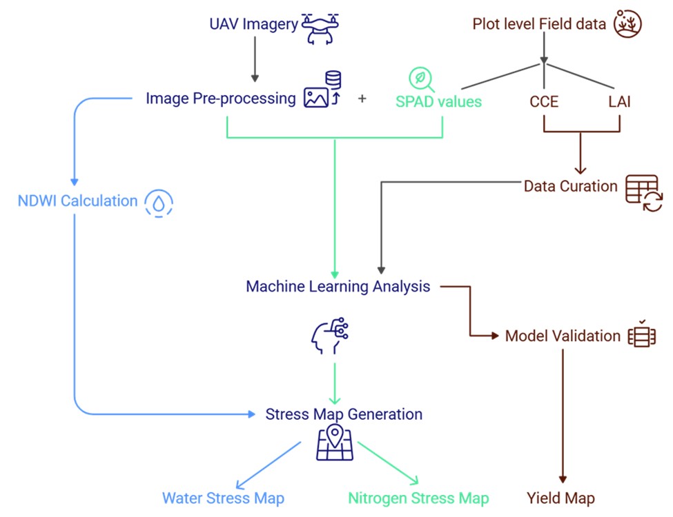
(Abbreviations: CCE-Crop cut experiment, LAI-Leaf Area Index)
Beyond UAVs: The Future of Smart Farming
While drones offer invaluable insights for precision agriculture, they come with challenges such as limited battery life, operational costs, and regulatory restrictions. However, combining UAV imagery with satellite remote sensing and AI-driven analytics can bridge these gaps, offering continuous, large-scale crop monitoring.
Future advancements may integrate UAVs with IoT-based sensors and automated decision-making systems, further enhancing real-time stress detection and predictive farming. By fusing multiple data sources, farmers and researchers can unlock smarter, more resilient agricultural systems that ensure food security for the future.
A Sky-High Solution for Ground-Level Challenges
In the face of climate uncertainties that challenge global agriculture, technology-driven solutions like UAV-based crop monitoring shine as a beacon of hope. By capturing high-resolution data and leveraging AI to analyze trends, drones are poised to revolutionize our approach to food production—ensuring sustainability from sky to soil.