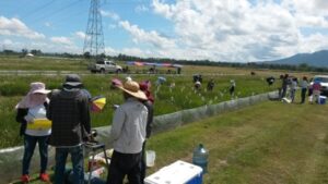
Researchers at the Chinese Academy of Sciences in Beijing have developed high-resolution maps with crucial information that will help study cloud-prone rice paddy cultivation in Northeast India and Bangladesh.
Using cloud-free Synthetic Aperture Radar images from Sentinel-1 satellite, the Random Forest classifier, and the Google Earth Engine cloud computing platform, the maps could provide governments and other agencies with valuable information for managing land and water resources more efficiently and promoting environmentally sustainable production to ensure global food security. They can also be useful in studying regional food security, freshwater use, and climate change as well as identifying flood-prone regions to mitigate crop production losses and damages.
Read the full story at India Science Wire
More on remote sensing imagery: