by Amit Kumar Srivastava, Suranjana Bhaswati Borah, Payel Ghosh Dastidar et al.
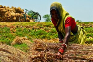
Around 80% of India’s rice production is from the eastern Indian states of Odisha, West Bengal, Bihar, Chhattisgarh, Jharkhand, Madhya Pradesh, and Assam. Rice is primarily cultivated in the kharif season; however, large areas remain fallow during the subsequent rabi season. There is tremendous potential to boost the cropping intensity and crop productivity to increase farmer income by targeting the rabi rice-fallow areas. However, there are significant knowledge gaps regarding where intensification is required, and therefore, it is imperative to use spatial analysis to identify the potential locations. Mapping the distribution of agricultural fallow lands across the different seasons is crucial for understanding where crop diversification and intensification could be encouraged. Satellite remote sensing is widely accepted as a reliable source of data for identifying and monitoring earth surface features with the benefit of synoptic and repeated coverage at varied resolutions, which are available for near real-time as well as historical measurements
Agricultural intensification is widely accepted as a viable solution to address the increasing demand for food worldwide rather than expanding the area under cultivation. The need for higher production can be met through higher yields from the same land, as an increase in the cropland results in a distressing environment.
Increasing sustainable cropping intensity can be a promising option to increase global food production by meeting rising food demands as well as providing additional income to farmers. In South Asia, rice is the predominant crop and is typically cultivated during a single season of a year, after which the area often remains unutilized during the other seasons. These unutilized areas are defined as rice fallows. Rice fallows extend over a large area (~22.3 million ha) in South Asia, with around 88.3% (~19.6 million ha) in India alone.
The unutilized areas have been of interest lately for their sustainable intensification with immense potential to increase the agricultural productivity of the country through effective targeting and appropriate crop management practices. In eastern India, rice is primarily cultivated in the kharif season; however, large areas remain fallow during the subsequent rabi season. Around 80% of India’s rice production is from the eastern Indian states of Odisha, West Bengal, Bihar, Chhattisgarh, Jharkhand, Madhya Pradesh, and Assam.
Several environmental and socioeconomic factors contribute to most of the farmers in eastern India not opting to grow a second crop after rice. The absence of irrigation facilities is a crucial factor leading to land remaining fallow after the rainy season, as the rapid depletion of residual soil moisture makes it challenging for farmers to sustain a second crop during the dry season.
Another contributing factor to farmers not choosing a rabi crop after the kharif rice harvest is the use of long-duration rice varieties that require a significant amount of time to mature (150–165 days), resulting in late harvesting. Additionally, there is a scarcity of appropriate short-duration and high-yielding superior varieties of other crops that could be grown during the rabi season.
Therefore, selecting the most suitable crop and employing the best crop establishment method is crucial to effectively use the soil moisture available in rice-fallow areas despite the existing challenges to maximize agricultural production.
There is tremendous potential to boost the cropping intensity and crop productivity to increase farmer income by targeting the rabi rice-fallow areas. The proper utilization of residual moisture and nutrients in suitable lowland areas for sowing a second crop in the rabi season after the preceding rice crop in kharif can contribute substantially to increasing productivity and income.
However, there are significant knowledge gaps regarding where intensification is required, and therefore, it is imperative to use spatial analysis to identify the potential locations. Mapping the distribution of agricultural fallow lands across the different seasons is crucial for understanding where crop diversification and intensification could be encouraged.
Satellite remote sensing is widely accepted as a reliable source of data for identifying and monitoring earth surface features with the benefit of synoptic and repeated coverage at varied resolutions, which are available for near real-time as well as historical measurements. Over the years, geospatial technologies have played a pivotal role in mapping agricultural practices.
The modal distribution and spectral profile of vegetation indices have been used to calculate the number of harvests and identify the number of cropping cycles in a year and the land that remains fallow thereafter.
This technology can also aid as an important tool for weighing the relative importance of various parameters of crop suitability analysis in fallow areas. Ancillary data such as agro-meteorological observations or topography and land use information, along with satellite data, were also additionally used to map multiple cropping areas with greater accuracy.
To identify underutilized lands during the rabi season, a decision tree classification approach on multi-spectral satellite images was use. Several studies have used satellite data from different types of sensors, including optical, thermal infrared, and microwave (active and passive) sensors, for the estimation of residual soil moisture after the kharif season as it is an essential parameter for planning the successive rabi crop in rain-fed fallow regions.
Rice is the major crop cultivated in Assam, with an estimated coverage of 2.36 million ha of the cropped area during two cropping seasons (kharif and rabi), and significantly contributes to the state’s total food grain production. Around 80% of the agricultural area is cropped with rice; however, this area is mostly during kharif, and most of the farmers rely on a single cropping pattern leaving their agricultural lands fallow during rabi.
Assam’s suitable climate and highly fertile alluvial soils can sustain several other crops, such as pulses and oilseeds. However, multiple cropping is only practiced in the belt adjacent to the Brahmaputra River. In Assam, most of the farmers are characterized as small and marginal, with an average land holding of less than 2 hectares, and are largely dependent on monsoon rain for agriculture.
Although several studies have discussed the existence of rice fallows in eastern and northeastern India, there are information gaps on the precise area and its characterization for the potential intensification of the state of Assam. The rice-fallow dynamics through multi-year analytics in northeastern India lack an adequate understanding, which is required to demarcate chronic areas and understand patterns for improved decision-making.
Our approach is to utilize earth observations and ground data to identify, target, and validate suitable areas for short-duration crops in rice fallows and demonstrate the feasibility of utilizing such areas in the farmers’ field by growing the crop. We aim to answer the characterization and targeting of the rice fallow by understanding:
(i) which variables govern the existence of rice-fallow and how effectively rice and rice-fallow areas can be mapped through earth observation data;
(ii) how the spatiotemporal variability of soil moisture be used for targeting agronomic interventions in cropping intensification; and
(iii) perform targeted agronomic trials, which can be accomplished in suitable rice fallow to indicate the potential of introducing short/medium duration crop sustenance.
Our study shows that the existence of rice-fallow areas is primarily governed by a lack of irrigation facilities and excessive soil moisture, which pose a major constraint for farmers when growing the next crop.
This study also revealed that using a combination of time-series satellite images, robust ground data, and a statistically suitable machine learning model such as random forest, the rice and rice-fallow areas could be effectively mapped, across multiple years, with a greater than 90% accuracy.
The high-accuracy maps are much needed to pinpoint regions for planning and targeting the appropriate interventions. We found that the combination of spatiotemporal soil moisture data products with variables, such as multiple sowing windows, to estimate suitability categories could be effectively mapped.
Soil moisture suitability can help understand the decision of farmers to plant crops in the case of the non-availability of sufficient irrigation facilities in space and time. We used the dynamics of the soil moisture and its suitability categories as proof of concept to target our agronomic intervention.
We observed that targeted agronomic trials, with suitable variety, best management practices, and only one irrigation gave a substantially high yield in areas that had remained fallow since the last two years before the trial. This, therefore, proved our concept that the targeted suitable rice-fallow areas identified through geospatial technology have the potential to be used for short/medium duration crop sustenance.
Through this study, we have emphasized that the efficient planning of appropriate agronomical interventions in suitable areas can promote sustainable cropping intensification in this region.
We found that the small land holding size and the existing geospatial data product at multiple resolutions posed a challenge in zeroing down to the area of intervention at the plot level.
An emphasis on developing a finer spatial and temporal soil moisture product is crucial for improved targeting. There is a need for reliable evidence and data to implement the proper planning for agricultural development and management to increase productivity and profitability.
The crop-specific suitability for rice-fallow areas remains the scope for further studies coupled with geospatial and agronomic information for crop diversification.
Read the study:
Srivastava AK, Borah SB, Ghosh Dastidar P, Sharma A. et al. (2023) Rice-Fallow Targeting for Cropping Intensification through Geospatial Technologies in the Rice Belt of Northeast India. Agriculture, 13, 1509.