In this study, we used radial kernel support vector machine (SVM) to map the crop types of smallholder farms in two sites in eastern India. We focused on using SVM because previous studies have suggested that it produces higher classification accuracies compared to other commonly used algorithms, including random forest, for supervised pixel-based classifications. We specifically focused on mapping four major crops (maize, mustard, tobacco, and wheat) planted during the dry winter season in Bihar, India
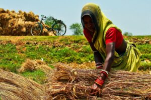
Smallholder farming comprises 12% of global agricultural lands and produces approximately 30% of the global food supply. Smallholder systems are being challenged by environmental change, including climate change and natural resource degradation.
Mapping agricultural land cover and land-use change (LCLUC) is critically important for understanding the impacts of environmental change on agricultural production and the ways to enhance production in the face of these changes. While remote sensing has been widely used to map agricultural LCLUC across the globe, it has historically been challenging to map smallholder agricultural systems given the small size of fields (<2 ha) relative to long-term, readily available imagery, such as Landsat and MODIS.
Over the last decade, however, new readily available sensors, including Sentinel-1, Sentinel-2, and Planet, have been launched and can provide higher-resolution datasets (<=10 m). These new sensors have been shown to better detect field-level characteristics in smallholder systems, and they have the potential to provide the critical datasets needed to improve
food security over the coming decades.
One key dataset for monitoring LCLUC in smallholder systems is crop type. This is because identifying crop types is an important precursor to mapping agricultural production, particularly yield, and studies have shown that crop switching is one of the main axes of adaptation to environmental changes in smallholder systems.
Yet, to date, relatively little work has been carried out to map crop types in smallholder systems compared to other agricultural characteristics, such as cropped area and yield. The work that does exist to map smallholder crop types using readily available imagery has largely focused on using Sentinel 1 and 2, yet it is likely that micro-satellite data could improve classification accuracies given their higher spatial resolution, which reduces the effect of mixed pixels at field edges.
To the best of our knowledge, only two studies have examined the benefits that Planet micro-satellite data provide when mapping smallholder crop types, and these two studies were conducted in Africa. To date, no work, to the best of our knowledge, has examined the ability of Planet satellite data to map crop types in India, which is the world’s largest nation of smallholder farms.
In this study, we used radial kernel support vector machine (SVM) to map the crop types of smallholder farms in two sites in eastern India. We focused on using SVM because previous studies have suggested that it produces higher classification accuracies compared to other commonly used algorithms, including random forest, for supervised pixel-based classifications.
We specifically focused on mapping four major crops (maize, mustard, tobacco, and wheat) planted during the dry winter season in Bihar, India. We used these data to ask three specific research questions:
- How accurately do Sentinel-1, Sentinel-2, and PlanetScope imagery map crop types in smallholder systems?
- Which sensor or sensor combinations lead to the greatest classification accuracies?
- Does crop type classification accuracy vary with farm size?
- Does adding Planet satellite data improve the classification accuracy more for the smallest farms?
- How does classification accuracy vary based on the timing of imagery used?
- Are there particular times during the growing season that lead to a better discrimination of crop types?
This study provides important insights into the ability of new, higher-resolution satellite data to map crop types in smallholder systems in India. Such information is critical given that readily available crop type maps do not exist across the country, and crop type information can be used to better understand the impacts of environmental change in this globally important agricultural region.
In this study, we assessed the ability of three readily available, high-resolution sensors (Sentinel-1, Sentinel-2, and Planet) to detect four major crop types across smallholder farming systems in eastern India. We found that using all three sensors led to the highest classification accuracy (85%).
Planet satellite imagery was important for classifying crop types in this system, leading to the greatest increases in classification accuracy, particularly for the smallest farms (<600 m2). Furthermore, our results suggest that using only imagery from the second half of the growing season is adequate to differentiate crop types in this system.
Overall, our results suggest that Sentinel-1, Sentinel-2, and PlanetScope imagery can be used to accurately map crop type, even in heterogeneous systems with small field sizes such as those in India.
Read the full study:
Rao P, Zhou W, Bhattarai N, Srivastava A.K, Singh B, Poonia S, Lobell DB, Jain M. (2021) Using Sentinel-1, Sentinel-2, and Planet Imagery to Map Crop Type of Smallholder Farms. Remote Sens. 13, 1870.