Rice researchers at the Texas A&M AgriLife Research Center launched a project that uses data collected by drones to speed up rice cultivar selection and breeding.
The project aims to use drones to capture real-time images of rice crops and analyze that information to discover superior, high-yielding rice genotypes.
Drone technology could potentially provide a cost-effective and reliable alternative to traditional manual measurement of rice phenotypic traits which is highly time-consuming and requires qualified experienced staff.
Read the story @EurekaAlert
More on drone technology application in agriculture:
Researchers use drones to study nutrient status, greenhouse gas emissions of rice crop
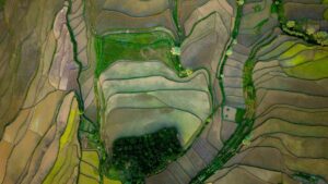
Unmanned aerial vehicle or drone footage provides a more integrated visual inspection of a rice field from above and makes it possible to gather more accurate, efficient, and location-specific data compared with traditional data-gathering instruments. Through remote sensing, drones are used to collect field data in the form of raw images that capture various indicators of nitrogen crop growth status, for example, the greenness of the leaf and the density of the canopy.
Plant phenomics: unlocking the potential of rice diversity
Drones provide an excellent means to collect data with which to sieve large collections of rice diversity for valuable traits. Fitted with RGB, spectral, and thermal imaging sensors, the drone can collect data at the farm scale—measuring up to 100 hectares of rice in an hour. Cheap, fast, and highly mobile, drones have proven so successful that they will be deployed globally as part of the RICE–Global Rice Array, a network that brings together an international community of rice scientists to conduct a joint effort in enhancing the power of phenomics.
Agricultural Drone Training
This course is designed to equip participants with the knowledge and skills in operating multicopters for various applications in agriculture, particularly utilizing drone digital mapping capabilities in monitoring crop health, and damage assessment to maximize production. Participants will get the opportunity to practice drone operation in the field.