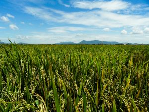
Global rice areas produced more than 690 million tons of rough rice in 2012.1 If we divide this by the number of seconds in a year, then—on average—nearly 22 tons or about 440 sacks (50 kilograms each) of rice were harvested every second. We do know, however, that such a simple calculation does not sufficiently account for the variations in planting and harvesting dates within a year and across all rice-growing areas. So, how much rice is harvested in a given location and at a given time?
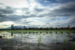
To estimate the distribution of the world’s rice production through the year, we compiled detailed rice planting and harvesting dates by growing season in all rice-growing areas from various sources and linked this global rice crop calendar database to detailed rice production statistics (Figs. 1 and 2). Information on when rice is planted and harvested, and the associated production in different locations, is important to better assess food security, and seasonal and geographic variations in food supply. Rice statistics are often available annually or, at best, by season in a few countries.
Information on monthly rice output can be used to analyze spatial and seasonal production trends in rice-producing countries, and to assess and predict price fluctuations in global, national, and local markets. This, together with information on climate shocks and rice stocks, can be useful for policymakers to better prepare for potential significant shortfalls in food production at certain times of the year.


The crop calendar currently used refers to average planting and harvesting dates in an area over several years. As a next step, we will use actual growing seasons derived from analyzing remotely sensed data, together with better estimates of the seasonal distribution of rice production used.
_________________________________________
Ms. Cuerdo, Ms. Villano, and Ms.Gutierrez are researchers and Ms.Garcia is a researcher and cartographer at IRRI.
Ms. Laborte is a GIS specialist at IRRI. Dr. Boschetti is a researcher at the Institute for Electromagnetic Sensing of the Environment (IREA-CNR).
Dr. Zwart is a remote-sensing and GIS specialist at Africa Rice Center.
Dr. Nelson is a geographer and head of the GIS laboratory at IRRI.